Design: open space and urban planning
Topic
Even in rural and suburban locations, industrial estates have developed over decades in a kind of shadowy existence, helping to support today's standard of living. In rural areas, there is also a new demand for space for small and medium-sized businesses. Industrial estates are places of consumption and production that have developed from the functional requirements of tradespeople. Due to their separate location from the town and village centres, they also enable 'quiet living in the countryside'. At the same time, the urban planning logic follows the principle of separating living and working. The resulting form lacks a spectrum of possible social, ecological and aesthetic qualities. The commercial sector is one of the drivers of the high level of new land utilisation (land consumption).
Area and analysis
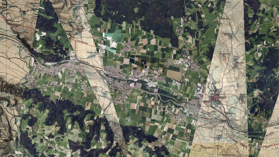
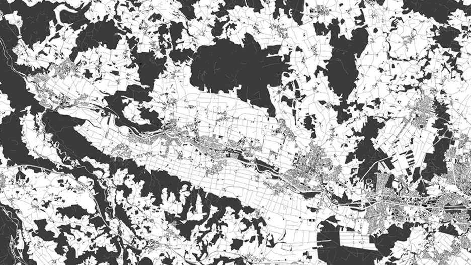
In the project, we analyse various commercial areas in the Lower Mangfall Valley (Feldkirchen-Westerham, Bruckmühl, Bad Abiling, Kolbermoor) - as well as their surrounding landscape. The landscape morphology and settlement structure of the valley is recorded in such a way that the types of commercial areas that have developed here can be categorised. To this end, we are visualising both the buildings and the cultural landscape as a texture. To this end, historical plans are analysed for lost qualities and starting points for new development are sought in the present. The aim is to understand where no texture has been created, but where buildings have been constructed schematically. The analysis will result in plans that are based on the drawing style of the Nolli plan on an urban planning level in order to emphasise the spatial quality of the existing buildings and to allow future developments to relate to the existing buildings.
Aim
In each design, a possible future development for the commercial areas of the valley is sketched out contextualistically (according to Rowe)[1] based on the existing building and landscape structures. The aim is to create social spaces and integrate housing in the sense of a mixed area. The designs are intended to show how industrial estates can become urban and village building blocks that become part of the landscape as well as part of the settlement body, thereby developing ecological and climatic added value. Using the stimulant method from 'Collage City' [1, 2], new structures will be inserted that create new textures or integrate into an existing texture and thus create a connection between the existing settlement area and the surrounding landscape. The typologies identified are to be further developed in terms of design, with urban planning work being developed: Volumes will be increased, densification will take place, open spaces will be utilised by several users at the same time and the open space will ultimately become multifunctional. The designs are intended to show how commercial areas can be redensified, creating added value for the entire community, how commercial areas can become social centres and how residential and commercial areas can be combined to save space.
[1] see Rowe, Colin und Fred Koetter. 1978. Collage City. MIT Press.
[2] Schäfer, Julian. 2023. Collage Landscape. Dissertation, mediaTUM.
Excursion
Excursion to the Lower Mangfall Valley
The Lower Mangfall Valley is characterized by the beauty of the foothills of the Alps and at the same time the location of highly visible industrial structures. Together we want to get an overview of the entire area by looking out over the entire valley from hilltops, as well as 'hiking' the industrial sites on foot. We will discuss the extent to which texture qualities are still or already present today - and how we can recreate them in the open landscape and on the edges of settlements in order to promote social interaction and encounters.
Bachelor-Studio
Students in their specialisation project 'Landscape' should interweave cultural landscape structures and urban structures in such a way that they create spaces in the sense of the change of aspect (Wittgenstein) that can be read both as components of the commercial areas and as structures of the surrounding landscape.
Master-Studio
In addition, the master's studio designs should conceptualise and design how the areas must be adapted to climate change in a forward-looking manner. As an integrated theoretical elaboration, it must therefore be demonstrated how a rainwater and energy system will function for the areas and how general ecological added value will be created.
Project phases
All appointments regularly take place on Mondays at 13:00 (in exceptional cases on Thursdays at 13:00). Details are subject to change. For information on the main content of the three phases, see: Design projects on a regional scale. Design projects on a regional scale.
Phase 1 Design analysis
The design analysis is about getting to know the space and its surroundings intensively - the excursion is central to this phase. During the excursion, we approach the specific analysis topics of the groups as well as their selected project areas and thematic focal points.
The planning goal can be...
- Understand and characterize landscapes (spatial types)
- To capture the textures of the landscape as a result of land use activities and techniques
- Recognize designable forms, functions and constructions typologically (discover a design repertoire)
- Develop initial ideas and concepts
PHASE 2 Concept.
Based on the results of the analysis and taking into account social, aesthetic, ecological and economic objectives of landscape development, a spatial concept & program should be developed, which can be based on individual cultural landscape elements and landscape structures and/or their interrelationships.
PHASE 3 Designing structures.
In phase 3, designs of elements/structures and/or structural contexts are developed at regional, urban planning, object planning and/or detail level, always taking into account the concept developed and consistent landscape development.
Approach and implementation.
SKETCHING. Sketching the spaces/landscape in pencil on tracing paper over (topographical) maps and aerial photographs. Draw through, search for elements and form types.
ANALYZING. Digital character maps (qGIS) are created, the significance of the spaces/landscapes and the typical landscape elements that characterize them from your point of view are compiled.
CONSTRUTE. Elements and structures of renewable energies are recorded in all their dimensions and varied as building blocks of landscape textures.
DESIGN. Merging and overlaying the digital data and sketched structures into landscape ideas.
Dates
Supervision always takes place on Mondays, from 1.00 pm; or in exceptional cases on Thursdays, from 1.00 pm. You can find a more detailed overview of the dates on Moodle.
Wed-Fri, 9-11 October 2024 Recommendation: Visit of the symposium 'Design-Related Research' (Munich)
Mon, 14 Oct 2024 _ Introduction Bachelor and Master, deadline for registration: 6 pm
Mon, 21 Oct 2024 _ Group formation and cartographic analysis (1st supervision of design analysis)
Fri, 25 Oct 2024 _ Visit to the Weihenstephan LAND CRED forum (in Freising-Weihenstephan)
Mon, 28 Oct 2024 _ 2nd supervision of design analysis
Mon, 04. Nov 2024 _ 3rd supervision of design analysis, excursion preparation
Thu - Mon, 07 Nov - 10 Nov 2024 _ Excursion to the Lower Mangfall Valley
Mon, 11 Nov 2024 – 4th supervision of design analysis
Mon, 18 Nov 2024 _ 5th supervision of design analysis
Mon, 25 Nov 2024 _ Presentation of design analysis (on printed plan)
Thu, 28 Nov 2024 _ Visit to the design area
Mon, 02 Dec 2024 _ 1st supervision of concept
Mon, 09 Dec 2024 _ 2nd concept supervision
Mon, 16 Dec 2024 _ Presentation concept (projector)
Mon, 13 Jan 2025 _ 1st support draft
Mon, 20 Jan 2025 _ 2nd draft supervision
Mon, 27 Jan 2025 _ 3rd draft supervision
Mon, 03 Feb 2025 _ Final presentation (projector and printed plan)
Mon, 10 Feb 2025 Submission Integration (Master only) digital as upload
